

 Flat maps really do no justice to a curvy city like San Francisco. It reminds me of the "wiggly" world of Alan Watts' "Conversations with Myself", filmed in Marin, in which he even says putting a grid pattern on the hills of San Francisco is a uniquely human folly that reveals our lack of sophistication in comparison to
  nature's graceful complexity.
Anyway, I came across a program to not only generate a wiggly map of San Francisco, but animate it and fly over. The image above is a still shot from that program, showing the areas described and photographed in this blog. The blue line is Polk Street, the white dot is where I live. The black circle is where the top of Nob Hill shots came from and the red circle is the Civic Center and Hastings.

Like a flat map, my camera also fails to do this town any justice, but in this pic to the left you can start to get the feel of Nob Hill ascending in front of you, even if it's just Pine Street, which doesn't hardly get to the same elevation as the streets just slightly north. In fact, when walking west back from the Financial or SOMA districts, Pine Street is the way to go unless you're looking for a serious hike.
Being away for the holidays, I lost touch a little with what was going on in the Bay Area. I was disgusted, shocked and appalled to learn a few days before I returned about the murder of Oscar Grant by an Oakland police officer at the Fruitville BART station on New Year's Day. The Bay Area Rapid Transit system (BART), is like the subway in most any major city, though it spends a good bit of time above ground, particularly in the East Bay, where Fruitville is located. While any police shooting is a tragedy, in this case video of the murder has surfaced showing Grant was unarmed and lying on his belly when he was shot.

When it became clear the officer responsible for the shooting would not be so much as reprimanded, protesters gathered at the Fruitville station. Despite the best intentions of the organizer and probably most of those present, they soon became rioters as spitting, fire-starting, looting and general pandemonium ensued.
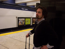
 The day this all occurred happened to be the day of my return, when I would be riding BART to the Civic Center/UN Plaza stop, shown above, on the very line that would eventually cross under the bay and past the site of the murder. During the whole ride, the BART central dispatch made announcements over the intercom updating the situation and alerting us the train would not be stopping at Fruitville for our safety. And this, too, is ultimately part of the topography of the Bay Area.
The culture of this progressive stronghold is nonetheless inseparable from the struggles required of the free and the brave. Down the street from the wealthiest, Blackberry-toting 20-something software execs is the greatest homeless population in the entire region. And amidst the beautiful natural scenery are some of the highest per capita murder rates in the country, some perpetrated by the police force itself. The Bay Area is the birthplace of both the United Nations and the Black Panther Party.

So, it's a weird and wiggly world, my friends. Happy New Year, and stay safe. I love you.
4 comments:
I always enjoy your posts... they are written so eloquently! I like the topographical map, but it'd be cool to see it at a 30 degree angle or something, instead of from above.
I heard all about the shooting. It has been on CNN a lot. So tragic! So unnecessary.
I enjoy your pix. Post more often!
I can't believe how well you can zoom in on that aerial map to see a pic of you in your place from above like that. Amazing!
Why is the date of this article Dec 5th?
thanks guys. apparently the blog dates posts from when i start them, and that one had been lying around unfinished since early december. the topo map is at a bit of an angle; i hope you can discern some of the different elevations.
Very scary!
Post a Comment